United States: pilot draws the Mona Lisa across two states with his flight path

Benjamin McDaniel flew his Cessna R182 for almost four hours over Oklahoma and Arkansas to trace Leonardo's portrait on the flight tracking maps. What the ADS-B data shows, and how you plan a flight like this.

By the PilotinQ editorial team · based on 13 sourcesPublished 18 Sep 2026, 18:00 UTC · 5 min read
LinkedInXWhatsAppFacebook
Left, Leonardo da Vinci's Mona Lisa; right, a dark line drawing of the same portrait formed by the flight path of a Cessna
Leonardo da Vinci's Mona Lisa next to the flight path of N1810R on 18 September 2026, drawn from adsb.lol ADS-B data. Track: adsb.lol ADS-B data (ODbL). Painting: Leonardo da Vinci, public domain via Wikimedia Commons · ODbL (track), public domain (painting)
IN SHORT
  • On 18 September 2026, Benjamin McDaniel flew a Cessna R182 from Bentonville, Arkansas, in a path that traced the Mona Lisa across the Oklahoma-Arkansas line.15
  • ADS-B data shows a flight of 3 hours and 47 minutes and a portrait about 56 kilometres tall, flown mostly between 8,200 and 10,400 feet.2
  • McDaniel, an Auburn aviation graduate and flight instructor, says the art began as a way to build hours and keep his stick and rudder skills sharp.83
  • He plans headings, speeds and performance in advance and hand flies each design.8

On the morning of 18 September 2026, a Cessna R182 Skylane RG took off from Bentonville Municipal Airport in northwest Arkansas and spent the next few hours flying what looked, at first, like a random scribble of turns on the flight tracking maps12. By late morning the line had closed into a portrait of the Mona Lisa, about 56 kilometres (35 miles) tall, laid across the state line between Oklahoma and Arkansas2.

The pilot is Benjamin McDaniel, who posts his flight path art under the name The Pilot Picasso34. The FAA aircraft registry lists N1810R as a 1978 Cessna R182 registered to him5. AirNav Radar wrote about the drawing while it was still being flown, as the arms were being added6, News 9 in Oklahoma reported it the same evening1, and CBS reported that the portrait took months of planning7.

What the ADS-B data shows

Open ADS-B data from adsb.lol shows N1810R leaving Bentonville at about 08:08 local time and landing back there at about 11:55, a flight of 3 hours and 47 minutes2. After a transit of roughly a quarter of an hour to the west, the aircraft spent more than three hours on the drawing itself. The finished figure measures about 56 kilometres from the top of the head to the hands and about 42 kilometres across2. Most of it lies in Oklahoma, east of Tahlequah, with the right-hand side of the figure, shoulder and arm, reaching into Arkansas around Siloam Springs2.
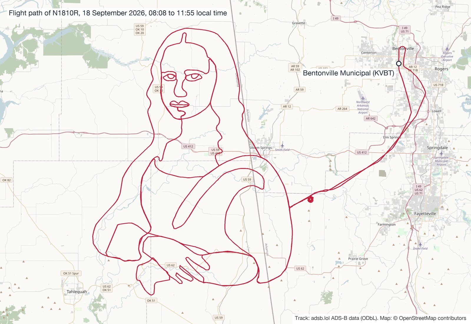
Map of northwest Arkansas and eastern Oklahoma with a red flight path in the shape of the Mona Lisa between Tahlequah and Siloam Springs, and a transit line to Bentonville Municipal Airport in the northeast
The flight path of N1810R on 18 September 2026, from adsb.lol ADS-B data. Map: OpenStreetMap contributors.

In total the aircraft covered roughly 780 kilometres (about 420 nautical miles), around 670 of them on the portrait2. During the drawing it flew mostly between 8,200 and 10,400 feet, rising from about 8,200 feet early in the drawing to a peak of around 10,400 feet towards 10:45, at typical groundspeeds of 95 to 125 knots2. The transponder showed code 1200, the standard code for VFR flight, from take-off to landing2. Reported flight times in the media range from about three and a half to five hours18; the 3 hours and 47 minutes in the ADS-B data run from take-off to landing.

Who is The Pilot Picasso

McDaniel graduated from Auburn University in Alabama in 2022 with a degree in aviation management, earned his instrument rating there and holds a commercial pilot certificate, a seaplane rating and a flight instructor certificate8. He instructed at Auburn and at a flight school in Alabaster, Alabama, and now flies for private and charter clients from Bentonville8. He bought his Cessna 182 in 20238, the year the FAA issued the current registration for N1810R5.

On his own site he writes that he has been flying since 2020 and that sky art began as a way to build hours and stay sharp: first simple shapes and words, then more ambitious drawings, all flown by hand in N1810R3. In early August he flew The One Ring and the Eye of Sauron from The Lord of the Rings in four and a half hours, about 30 miles wide, in the skies over Arkansas8.

Why he does it

"The art came about as a way to help hone my skills and keep on practicing by doing something a little different than flying airport to airport," McDaniel told Auburn University8. He hand flies the drawings rather than following GPS waypoints: "I hand fly it because it's a great way to keep up, as we call it, stick and rudder skills"8. Asked on local television why he does it, he answered: "For the challenge but also for the greater good," adding that he wants to show people messages that they might need that day9.

How you plan a flight like this

A drawing like this starts on the ground. McDaniel plans headings, speeds and aircraft performance in advance, and he sizes each design so the Cessna can fly every turn safely, usually at 8,000 to 10,000 feet8. In its article on the flight, Brookfield Aviation lists the other limits that shape a route like this: the shape of every turn, how long the aircraft can stay up, fuel, weather and airspace, all for an image the pilot cannot see from the cockpit10.

The aircraft cannot lift the pen, so the whole portrait is one continuous line. Every move from the eyes to the mouth or from the hair to the hands has to be flown, which is why some lines in the track run close together or double back on each other2. What the map shows is the track over the ground, not the heading, so any wind has to be corrected turn by turn to keep a curve where it belongs. That is the same wind correction every student pilot learns on a cross-country flight, only with far less room for error.

Fuel planning follows the normal rules. For a day VFR flight in the United States, a pilot must be able to reach the first point of intended landing and then fly for at least 30 more minutes at normal cruising speed11. On a sortie of almost four hours, that reserve has to be planned from the start, not found at the end.

Sky art and building hours

Drawing with a flight path is not new. In August 2017, a Boeing test crew flew a 787 Dreamliner for 18 hours over 22 US states during an engine test and traced the outline of a Dreamliner on the map12. What has changed is the audience. According to Auburn, about 73,000 people followed the Mona Lisa flight online and N1810R was the most tracked aircraft in the air that day8.

For aspiring pilots, the story is also about hours. A US commercial pilot certificate requires at least 250 hours of flight time13, and many pilots build a large part of those hours after their private licence. McDaniel turned that phase into a project that sharpens exactly the skills examiners look for: planning, holding a heading and altitude, and knowing where you are at every moment. If you are working towards a commercial licence, read what a CPL is and how the PPL works, see how to prepare to become a flight instructor, or look at the Auburn University aviation programme where McDaniel trained.

Frequently asked questions

Who drew the Mona Lisa with a flight path?

Benjamin McDaniel, a commercial pilot and flight instructor based in Bentonville, Arkansas, who posts his work as The Pilot Picasso38.

Which aircraft did he fly?

His own Cessna R182 Skylane RG, registration N1810R, built in 197856.

How big was the drawing and how long did it take?

About 56 kilometres tall and 42 kilometres wide, flown in a flight of 3 hours and 47 minutes from take-off to landing, according to ADS-B data2.

Timeline

  1. 2020
    McDaniel starts flying.3
  2. 2022
    He graduates from Auburn University in aviation management.8
  3. 2023
    He buys the Cessna 182 he uses for his drawings.8
  4. Aug 2026
    The Lord of the Rings drawing over Arkansas, four and a half hours.8
  5. 18 Sep 2026
    N1810R takes off from Bentonville Municipal Airport.2
  6. 18 Sep 2026
    Landing back at Bentonville after the Mona Lisa is complete.2
About:Cadet programmesAuburn University AviationFederal Aviation Administration
KEEP READINGANSWERWhat is a CPL?ANSWERPPL: costs, duration and requirementsANSWERHow to prepare to become a flight instructorFLIGHT SCHOOLAuburn University AviationAsk your own pilot question

Sources

  1. 1News 9 · Pilot draws Mona Lisa with flight path over Oklahoma-Arkansas line18 Sep 2026
  2. 2adsb.lol · ADS-B history for N1810R (hex A146CB), 18 September 202618 Sep 2026
  3. 3The Pilot Picasso · The Pilot Picasso: flight-path artwork
  4. 4The Tribune · Giant Mona Lisa in sky? US pilot 'draws' da Vinci's masterpiece across 2 states using aircraft route25 Sep 2026
  5. 5Federal Aviation Administration · FAA Registry: N-Number inquiry N1810R
  6. 6AirNav Radar · A Cessna Is Drawing the Mona Lisa in the Sky18 Sep 2026
  7. 7CBS News Texas · Pilot recreates "Mona Lisa" with flight path22 Sep 2026
  8. 8Auburn University · The Art of Flying: Auburn aviation grad 'Pilot Picasso' goes viral for flight tracker masterpieces7 Oct 2026
  9. 9KOAM · The "Pilot Picasso" shares his inspiration behind radar flight path photos6 Oct 2026
  10. 10Brookfield Aviation · Pilot Draws Mona Lisa in the Sky with a Cessna Flight Path2 Oct 2026
  11. 11eCFR · 14 CFR 91.151: Fuel requirements for flight in VFR conditions
  12. 12Fortune · A Boeing Dreamliner Drew an Enormous Outline of Itself Above the U.S.4 Aug 2017
  13. 13eCFR · 14 CFR 61.129: Aeronautical experience (commercial pilot)
CHANGES18 Sep 2026, 18:00 UTC · PublishedSpotted an error? Tell us, corrections are noted under the article.Every fact is checked against the sources listed above. How we work

More on cadet programmes

Sign in

United States: pilot draws the Mona Lisa across two states with his flight path

Benjamin McDaniel flew his Cessna R182 for almost four hours over Oklahoma and Arkansas to trace Leonardo's portrait on the flight tracking maps. What the ADS-B data shows, and how you plan a flight like this.

By the PilotinQ editorial team · based on 13 sourcesPublished 18 Sep 2026, 18:00 UTC · 5 min read
Left, Leonardo da Vinci's Mona Lisa; right, a dark line drawing of the same portrait formed by the flight path of a Cessna
Leonardo da Vinci's Mona Lisa next to the flight path of N1810R on 18 September 2026, drawn from adsb.lol ADS-B data. Track: adsb.lol ADS-B data (ODbL). Painting: Leonardo da Vinci, public domain via Wikimedia Commons · ODbL (track), public domain (painting)
IN SHORT
  • On 18 September 2026, Benjamin McDaniel flew a Cessna R182 from Bentonville, Arkansas, in a path that traced the Mona Lisa across the Oklahoma-Arkansas line.15
  • ADS-B data shows a flight of 3 hours and 47 minutes and a portrait about 56 kilometres tall, flown mostly between 8,200 and 10,400 feet.2
  • McDaniel, an Auburn aviation graduate and flight instructor, says the art began as a way to build hours and keep his stick and rudder skills sharp.83
  • He plans headings, speeds and performance in advance and hand flies each design.8

On the morning of 18 September 2026, a Cessna R182 Skylane RG took off from Bentonville Municipal Airport in northwest Arkansas and spent the next few hours flying what looked, at first, like a random scribble of turns on the flight tracking maps12. By late morning the line had closed into a portrait of the Mona Lisa, about 56 kilometres (35 miles) tall, laid across the state line between Oklahoma and Arkansas2.

The pilot is Benjamin McDaniel, who posts his flight path art under the name The Pilot Picasso34. The FAA aircraft registry lists N1810R as a 1978 Cessna R182 registered to him5. AirNav Radar wrote about the drawing while it was still being flown, as the arms were being added6, News 9 in Oklahoma reported it the same evening1, and CBS reported that the portrait took months of planning7.

What the ADS-B data shows

Open ADS-B data from adsb.lol shows N1810R leaving Bentonville at about 08:08 local time and landing back there at about 11:55, a flight of 3 hours and 47 minutes2. After a transit of roughly a quarter of an hour to the west, the aircraft spent more than three hours on the drawing itself. The finished figure measures about 56 kilometres from the top of the head to the hands and about 42 kilometres across2. Most of it lies in Oklahoma, east of Tahlequah, with the right-hand side of the figure, shoulder and arm, reaching into Arkansas around Siloam Springs2.

Map of northwest Arkansas and eastern Oklahoma with a red flight path in the shape of the Mona Lisa between Tahlequah and Siloam Springs, and a transit line to Bentonville Municipal Airport in the northeast
The flight path of N1810R on 18 September 2026, from adsb.lol ADS-B data. Map: OpenStreetMap contributors.

In total the aircraft covered roughly 780 kilometres (about 420 nautical miles), around 670 of them on the portrait2. During the drawing it flew mostly between 8,200 and 10,400 feet, rising from about 8,200 feet early in the drawing to a peak of around 10,400 feet towards 10:45, at typical groundspeeds of 95 to 125 knots2. The transponder showed code 1200, the standard code for VFR flight, from take-off to landing2. Reported flight times in the media range from about three and a half to five hours18; the 3 hours and 47 minutes in the ADS-B data run from take-off to landing.

Who is The Pilot Picasso

McDaniel graduated from Auburn University in Alabama in 2022 with a degree in aviation management, earned his instrument rating there and holds a commercial pilot certificate, a seaplane rating and a flight instructor certificate8. He instructed at Auburn and at a flight school in Alabaster, Alabama, and now flies for private and charter clients from Bentonville8. He bought his Cessna 182 in 20238, the year the FAA issued the current registration for N1810R5.

On his own site he writes that he has been flying since 2020 and that sky art began as a way to build hours and stay sharp: first simple shapes and words, then more ambitious drawings, all flown by hand in N1810R3. In early August he flew The One Ring and the Eye of Sauron from The Lord of the Rings in four and a half hours, about 30 miles wide, in the skies over Arkansas8.

Why he does it

"The art came about as a way to help hone my skills and keep on practicing by doing something a little different than flying airport to airport," McDaniel told Auburn University8. He hand flies the drawings rather than following GPS waypoints: "I hand fly it because it's a great way to keep up, as we call it, stick and rudder skills"8. Asked on local television why he does it, he answered: "For the challenge but also for the greater good," adding that he wants to show people messages that they might need that day9.

How you plan a flight like this

A drawing like this starts on the ground. McDaniel plans headings, speeds and aircraft performance in advance, and he sizes each design so the Cessna can fly every turn safely, usually at 8,000 to 10,000 feet8. In its article on the flight, Brookfield Aviation lists the other limits that shape a route like this: the shape of every turn, how long the aircraft can stay up, fuel, weather and airspace, all for an image the pilot cannot see from the cockpit10.

The aircraft cannot lift the pen, so the whole portrait is one continuous line. Every move from the eyes to the mouth or from the hair to the hands has to be flown, which is why some lines in the track run close together or double back on each other2. What the map shows is the track over the ground, not the heading, so any wind has to be corrected turn by turn to keep a curve where it belongs. That is the same wind correction every student pilot learns on a cross-country flight, only with far less room for error.

Fuel planning follows the normal rules. For a day VFR flight in the United States, a pilot must be able to reach the first point of intended landing and then fly for at least 30 more minutes at normal cruising speed11. On a sortie of almost four hours, that reserve has to be planned from the start, not found at the end.

Sky art and building hours

Drawing with a flight path is not new. In August 2017, a Boeing test crew flew a 787 Dreamliner for 18 hours over 22 US states during an engine test and traced the outline of a Dreamliner on the map12. What has changed is the audience. According to Auburn, about 73,000 people followed the Mona Lisa flight online and N1810R was the most tracked aircraft in the air that day8.

For aspiring pilots, the story is also about hours. A US commercial pilot certificate requires at least 250 hours of flight time13, and many pilots build a large part of those hours after their private licence. McDaniel turned that phase into a project that sharpens exactly the skills examiners look for: planning, holding a heading and altitude, and knowing where you are at every moment. If you are working towards a commercial licence, read what a CPL is and how the PPL works, see how to prepare to become a flight instructor, or look at the Auburn University aviation programme where McDaniel trained.

Frequently asked questions

Who drew the Mona Lisa with a flight path?

Benjamin McDaniel, a commercial pilot and flight instructor based in Bentonville, Arkansas, who posts his work as The Pilot Picasso38.

Which aircraft did he fly?

His own Cessna R182 Skylane RG, registration N1810R, built in 197856.

How big was the drawing and how long did it take?

About 56 kilometres tall and 42 kilometres wide, flown in a flight of 3 hours and 47 minutes from take-off to landing, according to ADS-B data2.

Timeline

  1. 2020
    McDaniel starts flying.3
  2. 2022
    He graduates from Auburn University in aviation management.8
  3. 2023
    He buys the Cessna 182 he uses for his drawings.8
  4. Aug 2026
    The Lord of the Rings drawing over Arkansas, four and a half hours.8
  5. 18 Sep 2026
    N1810R takes off from Bentonville Municipal Airport.2
  6. 18 Sep 2026
    Landing back at Bentonville after the Mona Lisa is complete.2
About:Cadet programmesAuburn University AviationFederal Aviation Administration
KEEP READINGANSWERWhat is a CPL?ANSWERPPL: costs, duration and requirementsANSWERHow to prepare to become a flight instructorFLIGHT SCHOOLAuburn University AviationAsk your own pilot question
PREPARETry a free aptitude lite testStart free

Sources

  1. 1News 9 · Pilot draws Mona Lisa with flight path over Oklahoma-Arkansas line18 Sep 2026
  2. 2adsb.lol · ADS-B history for N1810R (hex A146CB), 18 September 202618 Sep 2026
  3. 3The Pilot Picasso · The Pilot Picasso: flight-path artwork
  4. 4The Tribune · Giant Mona Lisa in sky? US pilot 'draws' da Vinci's masterpiece across 2 states using aircraft route25 Sep 2026
  5. 5Federal Aviation Administration · FAA Registry: N-Number inquiry N1810R
  6. 6AirNav Radar · A Cessna Is Drawing the Mona Lisa in the Sky18 Sep 2026
  7. 7CBS News Texas · Pilot recreates "Mona Lisa" with flight path22 Sep 2026
  8. 8Auburn University · The Art of Flying: Auburn aviation grad 'Pilot Picasso' goes viral for flight tracker masterpieces7 Oct 2026
  9. 9KOAM · The "Pilot Picasso" shares his inspiration behind radar flight path photos6 Oct 2026
  10. 10Brookfield Aviation · Pilot Draws Mona Lisa in the Sky with a Cessna Flight Path2 Oct 2026
  11. 11eCFR · 14 CFR 91.151: Fuel requirements for flight in VFR conditions
  12. 12Fortune · A Boeing Dreamliner Drew an Enormous Outline of Itself Above the U.S.4 Aug 2017
  13. 13eCFR · 14 CFR 61.129: Aeronautical experience (commercial pilot)
CHANGES18 Sep 2026, 18:00 UTC · PublishedSpotted an error? Tell us, corrections are noted under the article.Every fact is checked against the sources listed above. How we work

More on cadet programmes

CADET PROGRAMMESIndia: Air India wins DGCA approval for its flying academy in Amravati1 Nov 2026 · 3 min
CADET PROGRAMMESIndia: Skyborne signs 48 IndiGo cadets, its largest intake since the partnership began23 Oct 2026 · 4 min
CADET PROGRAMMESUnited States: Pan Am Flight Academy and Professional Pilots of Tomorrow partner on mentoring and ATP-CTP access22 Oct 2026 · 5 min