US: Nine killed as Bahamas-bound Learjet 60 crashes near homes in Palm Beach County, Florida

N722BD was en route from Austin to North Eleuthera when the crew reported ice, turbulence and an overspeed. The jet fell from FL350 to 8,750 feet in 76 seconds and hit a road in a residential area. All nine on board died.

By the PilotinQ editorial team · based on 21 sourcesPublished 1 Nov 2026, 23:06 UTC · Updated 3 Nov 2026 · 7 min read
LinkedInXWhatsAppFacebook
Sheriff vehicles and police tape on a wet, lit road in the evening
Sheriff's cordon near the crash site on the evening of 1 November. Photo: 12george1 via Wikimedia Commons · CC0
IN SHORT
  • Learjet 60 N722BD (MSN 60-271) crashed in Palm Beach County, Florida, on 1 November, killing all nine people on board.23
  • The flight from Austin (KAUS) to North Eleuthera (MYEH) was en route at FL350 when the crew reported ice, turbulence and precipitation.110
  • After a request to climb to FL370 came a distress call reporting an overspeed; in 76 seconds the jet fell to 8,750 feet.15
  • The governor said there were no reports of casualties on the ground; about 600 residents were moved out.36
  • The NTSB is leading the investigation. The cause has not been released.311

All nine people on board a Learjet 60, registration N722BD, died on Sunday 1 November when the business jet crashed in Palm Beach County, Florida, in the United States13. The aircraft was at 35,000 feet on its way from Austin, Texas, to North Eleuthera in the Bahamas when the crew reported ice, turbulence and precipitation and asked for a higher level13. A distress call reporting an overspeed followed shortly afterwards. The FAA says the jet went from 35,250 to 8,750 feet in a little over a minute59. No cause is known. The National Transportation Safety Board is leading the investigation with FAA support6.

Listen to the ATC audio of N722BD with Miami Center, with a timeline and quotes.

What the crew reported, what the NTSB is doing now and what the FAA says about ice at high altitude is covered in our follow-up report.

Flight data at a glance

  • Callsign: N722BD in the ADS-B data1. No flight number has been published.
  • Registration and Mode S code: N722BD, A9AB172.
  • Type: Learjet Inc. Model 60 (ICAO type code LJ60), serial number (MSN) 60-27112. It is not the 60XR configuration, which starts at serial 60-319 according to the type certificate12.
  • Engines: two Pratt & Whitney Canada PW305A turbofans, the standard engine for the type1112.
  • Year built: 2004 according to Flightradar24 and BizJet Journal; the FAA registry gives no year1211.
  • Registered owner: LR60271 LLC, Wilmington, Delaware, with a certificate dated January 20232.
  • Operator: Aurora Aviation. The flight was conducted under Part 135, according to the NTSB17.
  • Departure: Austin-Bergstrom International (KAUS) at 15:37 UTC. The runway has not been released; the ADS-B positions point to runway 36R1.
  • Destination: North Eleuthera (MYEH), Bahamas10.
  • Time: 1 November, last ADS-B position at 17:49 UTC, around 12:50 p.m. local time (EST) according to the FAA16.
  • Phase of flight: en route, cruising at FL3501.
  • On board: nine people, two flight crew and seven passengers. There were no survivors317.

From FL410 to FL350

The aircraft had flown from Little Rock, Arkansas, to Austin on 31 October1. On 1 November it took off to the north at 15:37 UTC, 10:37 a.m. in Florida, then turned east1. It cruised at 41,000 feet. Shortly after 17:35 UTC, near Naples, it began a descent to 35,000 feet, reached at about 17:411. Why the crew chose that level has not been released. The track then ran at about 050 degrees, and at 17:47 the aircraft turned right to about 100 degrees1.

76 seconds in the ADS-B data

At 17:48:07 UTC the aircraft transmitted an altitude of 35,250 feet after a brief climb1. At 17:48:39 that was 31,350 feet, and at 17:48:48 it was 28,325 feet with the highest groundspeed in the series: 506 knots1. The ground track then swung further and further right, from 115 degrees through 180 degrees at 16,725 feet to 219 degrees at 8,750 feet at 17:49:231. That is 26,500 feet in 76 seconds, an average of almost 21,000 feet per minute. Flightradar24 says the reported vertical rate exceeded 32,000 feet per minute, while the FAA puts the descent at about 350 feet per second19. The last position, at 17:49:31, shows a ground track of 277 degrees at 231 knots1. These are groundspeeds from raw ADS-B data, not indicated airspeeds or Mach numbers.

Dashcam view of a wet road with an aircraft descending steeply, circled in red
Dashcam image of the Learjet just before impact, with a red circle around the aircraft.

What the crew told Miami Center

No transcript has been released by the investigators. The recording of the exchange with Miami Air Route Traffic Control Center is on LiveATC.net and has been described by AP, CNN, CBS, AIN and Flightradar24134510. A pilot reports ice, an outside air temperature of minus 47 degrees Celsius and moderate turbulence moving the aircraft by as much as 700 feet34. "We have light, clear ice that is manageable and moderate turbulence," the pilot says3. The crew asks whether there is a better ride ahead110.

The crew then reports precipitation and asks to climb to 37,000 feet1310. Shortly after controllers issue climb instructions, the distress call comes1. The pilot first reports a descent of 8,000 and then 10,000 feet per minute3. "We are in an overspeed condition descending 20,000 feet per minute," the pilot then says5. About 30 seconds later the transmissions end with the words "we're out of time"510. Controllers try without success to re-establish contact10.

Weather: storms in the area, convective SIGMET in force

Storms were moving through the area and CNN reports that an FAA convective SIGMET for thunderstorms covered it4. The aircraft passed through a stronger cell a few minutes before the descent; CNN says it is unclear whether that played a part4. The nearest METAR comes from Palm Beach County Park Airport (KLNA), about 5 km from the crash site13:

  • KLNA 011735Z AUTO 12007G19KT 3SM VCTS SCT023 BKN029 OVC037 26/22 A3008
  • KLNA 011755Z AUTO 09012G19KT 7SM VCTS OVC021 27/22 A3007

Those surface observations say little about conditions at 35,000 feet, where the crew's report is the only public observation. A flood watch was in force for the region through Monday afternoon3.
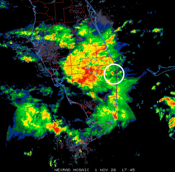
Radar image of southern Florida with storms and a white circle around the crash area
NEXRAD radar mosaic at 17:45 UTC, minutes before the crash. The circle roughly marks the crash area. Image: NEXRAD via College of DuPage and Wikimedia Commons, public domain.

Mmo and recovering from a steep dive

Mmo is the maximum operating limit speed expressed as a Mach number, which may not be deliberately exceeded in any phase of flight15. On the Learjet 60 it is about Mach 0.81 at high altitude, with a maximum operating altitude of 51,000 feet1112. An overspeed call describes the state of the aircraft, not what caused it.

The FAA upset recovery training aid, written for large transport aircraft, gives this sequence for a nose-low, high-speed situation: recognise and confirm the situation, disengage the autopilot and autothrottle, apply nose-up elevator, cautiously use stabilizer trim if needed, reduce thrust and extend speedbrakes if required14. It warns that a very clean aircraft can quickly exceed its limits and that g and airspeed limits must be respected14. What the crew did in the cockpit is not known.

A crater in Military Trail, hundreds moved from their homes

The aircraft came down at Military Trail, between Cresthaven Boulevard and 10th Avenue North, near Greenacres46. The site is about four miles south of the West Palm Beach airport4. Video from drivers shows flames, pieces of pavement and a crater; AP reports debris landing feet from houses and inches from passing vehicles3. Governor Ron DeSantis called the crash "cataclysmic" at a news conference and said there were no reports of anyone on the ground being killed or injured36. According to the NTSB, a man in a vehicle leaving the area next to the impact site later suffered a leg injury17. "Debris hit my house. Everything was on fire," resident Anthony Blackmon told NBC 68.

Police tape, debris and broken pavement beside the road, with a white car and emergency vehicles at dusk
Cordon at the crash site in the evening, with debris, broken pavement and a white vehicle.

About 600 people from a nearby mobile home community were moved out, with two shelters available346. Some people in the surrounding area lost power6. Military Trail is closed between 10th Avenue North and Purdy Lane/Alameda Drive until further notice, and how long that lasts depends partly on the federal investigation6. John I. Leonard High School stayed closed on Monday7.


The investigation

The NTSB sent a go-team, with investigators due on Sunday and Monday morning, and announced a media briefing in West Palm Beach for Monday 2 November35. The NTSB held its first media briefing on 2 November; what it said is covered in our report on the briefing17. According to her family, the co-pilot was Nathalia Gadelha Filgueiras, 201819. According to their family, Adam Robinson and Helen Sharp were also on board with their two young children2021. The names of the others on board have not been released.

NTSB records make this the second-deadliest crash in the United States this year, after a skydiving aircraft accident at Butler, Missouri, in June that killed 124.

The Learjet 60

The Learjet 60 is a twin-engine business jet with a low swept wing with winglets, rear-mounted engines and a T-tail12. The type received its US type certificate on 15 January 1993 and requires two pilots1112. Flight Safety Foundation data makes this the deadliest accident with the type4. In the previous fatal accident cited by CNN, four people died in 2008 when N999LJ overran the runway after a rejected takeoff at Columbia, South Carolina416.

About:SafetyLearjet 60National Transportation Safety BoardFederal Aviation AdministrationPalm Beach County
KEEP READINGNEWSMore safety newsAsk your own pilot question

Sources

  1. 1Flightradar24 · Learjet 60 crashes near West Palm Beach, Florida (with published ADS-B data)1 Nov 2026
  2. 2FAA Aircraft Registry · N-Number Inquiry N722BD2 Nov 2026
  3. 3Associated Press (via ABC7) · All 9 people died on jet that crashed into Florida neighborhood2 Nov 2026
  4. 4CNN (via WPSD Local 6) · 9 killed after a Learjet crashes and erupts into flames in Palm Beach County, Florida1 Nov 2026
  5. 5CBS Miami · Jet from Texas carrying 9 people crashes in Palm Beach, Florida1 Nov 2026
  6. 6WPTV · Hundreds displaced, portion of Military Trail closed indefinitely after deadly Palm Beach County Learjet crash1 Nov 2026
  7. 7WPTV · John I. Leonard High School announces Monday closure in wake of Learjet crash1 Nov 2026
  8. 8NBC 6 South Florida · 9 dead in Palm Beach County Learjet 60 crash1 Nov 2026
  9. 9ABC News · Learjet with 9 aboard crashes in Palm Beach County, Florida: FAA1 Nov 2026
  10. 10Aviation International News · Florida Learjet Crash Claims Nine1 Nov 2026
  11. 11BizJet Journal · Learjet 60 N722BD Crash Near West Palm Beach Kills Nine1 Nov 2026
  12. 12EASA · Type Certificate Data Sheet EASA.IM.A.212, Learjet Model 60, Issue 0412 Nov 2024
  13. 13Iowa Environmental Mesonet · METAR archive KLNA, 1 November 20261 Nov 2026
  14. 14FAA · Airplane Upset Recovery Training Aid, Revision 21 Nov 2008
  15. 15eCFR · 14 CFR 25.1505, Maximum operating limit speed2 Nov 2026
  16. 16NTSB · Aircraft Accident Report AAR-10/02, Runway Overrun During Rejected Takeoff, Learjet 60 N999LJ
  17. 17NTSB · NTSB Media Briefing 1, Palm Beach County, FL Learjet 60 Airplane Crash (Nov. 2, 2026)2 Nov 2026
  18. 18Local 10 News · Families ID victims in Palm Beach County jet crash that left 9 dead2 Nov 2026
  19. 19New York Post · Nathalia Gadelha identified as Learjet co-pilot in Florida crash2 Nov 2026
  20. 20ABC News · Parents and 2 young children among victims of Learjet crash in Florida, family says2 Nov 2026
  21. 21The Palm Beach Post (via Yahoo News) · Passengers in deadly Florida Learjet crash identified2 Nov 2026
CHANGES3 Nov 2026, 06:13 UTC · Updated: Added the parents who, according to their family, were on board.3 Nov 2026, 00:19 UTC · Updated: Added the name of the co-pilot as confirmed by her family.2 Nov 2026, 18:55 UTC · Updated: Updated after the NTSB briefing: operator, crew and passenger numbers, and an injury on the ground.2 Nov 2026, 08:57 UTC · Updated: Expanded with flight data, flight profile, radio calls, weather, images and video.1 Nov 2026, 23:06 UTC · PublishedSpotted an error? Tell us, corrections are noted under the article.Every fact is checked against the sources listed above. How we work
NEXT IN THIS DOSSIERUS: Learjet 60 crew reported ice at FL350 and minus 47 degrees before Florida crash, NTSB investigation under way

More on safety

Sign in

US: Nine killed as Bahamas-bound Learjet 60 crashes near homes in Palm Beach County, Florida

N722BD was en route from Austin to North Eleuthera when the crew reported ice, turbulence and an overspeed. The jet fell from FL350 to 8,750 feet in 76 seconds and hit a road in a residential area. All nine on board died.

By the PilotinQ editorial team · based on 21 sourcesPublished 1 Nov 2026, 23:06 UTC · Updated 3 Nov 2026 · 7 min read
Sheriff vehicles and police tape on a wet, lit road in the evening
Sheriff's cordon near the crash site on the evening of 1 November. Photo: 12george1 via Wikimedia Commons · CC0
IN SHORT
  • Learjet 60 N722BD (MSN 60-271) crashed in Palm Beach County, Florida, on 1 November, killing all nine people on board.23
  • The flight from Austin (KAUS) to North Eleuthera (MYEH) was en route at FL350 when the crew reported ice, turbulence and precipitation.110
  • After a request to climb to FL370 came a distress call reporting an overspeed; in 76 seconds the jet fell to 8,750 feet.15
  • The governor said there were no reports of casualties on the ground; about 600 residents were moved out.36
  • The NTSB is leading the investigation. The cause has not been released.311

All nine people on board a Learjet 60, registration N722BD, died on Sunday 1 November when the business jet crashed in Palm Beach County, Florida, in the United States13. The aircraft was at 35,000 feet on its way from Austin, Texas, to North Eleuthera in the Bahamas when the crew reported ice, turbulence and precipitation and asked for a higher level13. A distress call reporting an overspeed followed shortly afterwards. The FAA says the jet went from 35,250 to 8,750 feet in a little over a minute59. No cause is known. The National Transportation Safety Board is leading the investigation with FAA support6.

Listen to the ATC audio of N722BD with Miami Center, with a timeline and quotes.

What the crew reported, what the NTSB is doing now and what the FAA says about ice at high altitude is covered in our follow-up report.

Flight data at a glance

  • Callsign: N722BD in the ADS-B data1. No flight number has been published.
  • Registration and Mode S code: N722BD, A9AB172.
  • Type: Learjet Inc. Model 60 (ICAO type code LJ60), serial number (MSN) 60-27112. It is not the 60XR configuration, which starts at serial 60-319 according to the type certificate12.
  • Engines: two Pratt & Whitney Canada PW305A turbofans, the standard engine for the type1112.
  • Year built: 2004 according to Flightradar24 and BizJet Journal; the FAA registry gives no year1211.
  • Registered owner: LR60271 LLC, Wilmington, Delaware, with a certificate dated January 20232.
  • Operator: Aurora Aviation. The flight was conducted under Part 135, according to the NTSB17.
  • Departure: Austin-Bergstrom International (KAUS) at 15:37 UTC. The runway has not been released; the ADS-B positions point to runway 36R1.
  • Destination: North Eleuthera (MYEH), Bahamas10.
  • Time: 1 November, last ADS-B position at 17:49 UTC, around 12:50 p.m. local time (EST) according to the FAA16.
  • Phase of flight: en route, cruising at FL3501.
  • On board: nine people, two flight crew and seven passengers. There were no survivors317.

From FL410 to FL350

The aircraft had flown from Little Rock, Arkansas, to Austin on 31 October1. On 1 November it took off to the north at 15:37 UTC, 10:37 a.m. in Florida, then turned east1. It cruised at 41,000 feet. Shortly after 17:35 UTC, near Naples, it began a descent to 35,000 feet, reached at about 17:411. Why the crew chose that level has not been released. The track then ran at about 050 degrees, and at 17:47 the aircraft turned right to about 100 degrees1.

76 seconds in the ADS-B data

At 17:48:07 UTC the aircraft transmitted an altitude of 35,250 feet after a brief climb1. At 17:48:39 that was 31,350 feet, and at 17:48:48 it was 28,325 feet with the highest groundspeed in the series: 506 knots1. The ground track then swung further and further right, from 115 degrees through 180 degrees at 16,725 feet to 219 degrees at 8,750 feet at 17:49:231. That is 26,500 feet in 76 seconds, an average of almost 21,000 feet per minute. Flightradar24 says the reported vertical rate exceeded 32,000 feet per minute, while the FAA puts the descent at about 350 feet per second19. The last position, at 17:49:31, shows a ground track of 277 degrees at 231 knots1. These are groundspeeds from raw ADS-B data, not indicated airspeeds or Mach numbers.

Dashcam view of a wet road with an aircraft descending steeply, circled in red
Dashcam image of the Learjet just before impact, with a red circle around the aircraft.

What the crew told Miami Center

No transcript has been released by the investigators. The recording of the exchange with Miami Air Route Traffic Control Center is on LiveATC.net and has been described by AP, CNN, CBS, AIN and Flightradar24134510. A pilot reports ice, an outside air temperature of minus 47 degrees Celsius and moderate turbulence moving the aircraft by as much as 700 feet34. "We have light, clear ice that is manageable and moderate turbulence," the pilot says3. The crew asks whether there is a better ride ahead110.

The crew then reports precipitation and asks to climb to 37,000 feet1310. Shortly after controllers issue climb instructions, the distress call comes1. The pilot first reports a descent of 8,000 and then 10,000 feet per minute3. "We are in an overspeed condition descending 20,000 feet per minute," the pilot then says5. About 30 seconds later the transmissions end with the words "we're out of time"510. Controllers try without success to re-establish contact10.

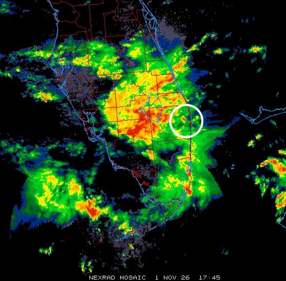
Weather: storms in the area, convective SIGMET in force

Storms were moving through the area and CNN reports that an FAA convective SIGMET for thunderstorms covered it4. The aircraft passed through a stronger cell a few minutes before the descent; CNN says it is unclear whether that played a part4. The nearest METAR comes from Palm Beach County Park Airport (KLNA), about 5 km from the crash site13:

  • KLNA 011735Z AUTO 12007G19KT 3SM VCTS SCT023 BKN029 OVC037 26/22 A3008
  • KLNA 011755Z AUTO 09012G19KT 7SM VCTS OVC021 27/22 A3007

Those surface observations say little about conditions at 35,000 feet, where the crew's report is the only public observation. A flood watch was in force for the region through Monday afternoon3.

Radar image of southern Florida with storms and a white circle around the crash area
NEXRAD radar mosaic at 17:45 UTC, minutes before the crash. The circle roughly marks the crash area. Image: NEXRAD via College of DuPage and Wikimedia Commons, public domain.

Mmo and recovering from a steep dive

Mmo is the maximum operating limit speed expressed as a Mach number, which may not be deliberately exceeded in any phase of flight15. On the Learjet 60 it is about Mach 0.81 at high altitude, with a maximum operating altitude of 51,000 feet1112. An overspeed call describes the state of the aircraft, not what caused it.

The FAA upset recovery training aid, written for large transport aircraft, gives this sequence for a nose-low, high-speed situation: recognise and confirm the situation, disengage the autopilot and autothrottle, apply nose-up elevator, cautiously use stabilizer trim if needed, reduce thrust and extend speedbrakes if required14. It warns that a very clean aircraft can quickly exceed its limits and that g and airspeed limits must be respected14. What the crew did in the cockpit is not known.

A crater in Military Trail, hundreds moved from their homes

The aircraft came down at Military Trail, between Cresthaven Boulevard and 10th Avenue North, near Greenacres46. The site is about four miles south of the West Palm Beach airport4. Video from drivers shows flames, pieces of pavement and a crater; AP reports debris landing feet from houses and inches from passing vehicles3. Governor Ron DeSantis called the crash "cataclysmic" at a news conference and said there were no reports of anyone on the ground being killed or injured36. According to the NTSB, a man in a vehicle leaving the area next to the impact site later suffered a leg injury17. "Debris hit my house. Everything was on fire," resident Anthony Blackmon told NBC 68.

Police tape, debris and broken pavement beside the road, with a white car and emergency vehicles at dusk
Cordon at the crash site in the evening, with debris, broken pavement and a white vehicle.

About 600 people from a nearby mobile home community were moved out, with two shelters available346. Some people in the surrounding area lost power6. Military Trail is closed between 10th Avenue North and Purdy Lane/Alameda Drive until further notice, and how long that lasts depends partly on the federal investigation6. John I. Leonard High School stayed closed on Monday7.

The investigation

The NTSB sent a go-team, with investigators due on Sunday and Monday morning, and announced a media briefing in West Palm Beach for Monday 2 November35. The NTSB held its first media briefing on 2 November; what it said is covered in our report on the briefing17. According to her family, the co-pilot was Nathalia Gadelha Filgueiras, 201819. According to their family, Adam Robinson and Helen Sharp were also on board with their two young children2021. The names of the others on board have not been released.

NTSB records make this the second-deadliest crash in the United States this year, after a skydiving aircraft accident at Butler, Missouri, in June that killed 124.

The Learjet 60

The Learjet 60 is a twin-engine business jet with a low swept wing with winglets, rear-mounted engines and a T-tail12. The type received its US type certificate on 15 January 1993 and requires two pilots1112. Flight Safety Foundation data makes this the deadliest accident with the type4. In the previous fatal accident cited by CNN, four people died in 2008 when N999LJ overran the runway after a rejected takeoff at Columbia, South Carolina416.

About:SafetyLearjet 60National Transportation Safety BoardFederal Aviation AdministrationPalm Beach County
KEEP READINGNEWSMore safety newsAsk your own pilot question

Sources

  1. 1Flightradar24 · Learjet 60 crashes near West Palm Beach, Florida (with published ADS-B data)1 Nov 2026
  2. 2FAA Aircraft Registry · N-Number Inquiry N722BD2 Nov 2026
  3. 3Associated Press (via ABC7) · All 9 people died on jet that crashed into Florida neighborhood2 Nov 2026
  4. 4CNN (via WPSD Local 6) · 9 killed after a Learjet crashes and erupts into flames in Palm Beach County, Florida1 Nov 2026
  5. 5CBS Miami · Jet from Texas carrying 9 people crashes in Palm Beach, Florida1 Nov 2026
  6. 6WPTV · Hundreds displaced, portion of Military Trail closed indefinitely after deadly Palm Beach County Learjet crash1 Nov 2026
  7. 7WPTV · John I. Leonard High School announces Monday closure in wake of Learjet crash1 Nov 2026
  8. 8NBC 6 South Florida · 9 dead in Palm Beach County Learjet 60 crash1 Nov 2026
  9. 9ABC News · Learjet with 9 aboard crashes in Palm Beach County, Florida: FAA1 Nov 2026
  10. 10Aviation International News · Florida Learjet Crash Claims Nine1 Nov 2026
  11. 11BizJet Journal · Learjet 60 N722BD Crash Near West Palm Beach Kills Nine1 Nov 2026
  12. 12EASA · Type Certificate Data Sheet EASA.IM.A.212, Learjet Model 60, Issue 0412 Nov 2024
  13. 13Iowa Environmental Mesonet · METAR archive KLNA, 1 November 20261 Nov 2026
  14. 14FAA · Airplane Upset Recovery Training Aid, Revision 21 Nov 2008
  15. 15eCFR · 14 CFR 25.1505, Maximum operating limit speed2 Nov 2026
  16. 16NTSB · Aircraft Accident Report AAR-10/02, Runway Overrun During Rejected Takeoff, Learjet 60 N999LJ
  17. 17NTSB · NTSB Media Briefing 1, Palm Beach County, FL Learjet 60 Airplane Crash (Nov. 2, 2026)2 Nov 2026
  18. 18Local 10 News · Families ID victims in Palm Beach County jet crash that left 9 dead2 Nov 2026
  19. 19New York Post · Nathalia Gadelha identified as Learjet co-pilot in Florida crash2 Nov 2026
  20. 20ABC News · Parents and 2 young children among victims of Learjet crash in Florida, family says2 Nov 2026
  21. 21The Palm Beach Post (via Yahoo News) · Passengers in deadly Florida Learjet crash identified2 Nov 2026

CHANGES3 Nov 2026, 06:13 UTC · Updated: Added the parents who, according to their family, were on board.3 Nov 2026, 00:19 UTC · Updated: Added the name of the co-pilot as confirmed by her family.2 Nov 2026, 18:55 UTC · Updated: Updated after the NTSB briefing: operator, crew and passenger numbers, and an injury on the ground.2 Nov 2026, 08:57 UTC · Updated: Expanded with flight data, flight profile, radio calls, weather, images and video.1 Nov 2026, 23:06 UTC · PublishedSpotted an error? Tell us, corrections are noted under the article.Every fact is checked against the sources listed above. How we work
DOSSIER · ONGOINGUS: Learjet 60 N722BD crash in Palm Beach County, Florida4 articles since 1 Nov 2026 · this is part 1Open the dossier
NEXT IN THIS DOSSIERUS: Learjet 60 crew reported ice at FL350 and minus 47 degrees before Florida crash, NTSB investigation under way

More on safety

SAFETYUS: Listen to the ATC audio of Learjet 60 N722BD before the crash in Florida3 Nov 2026 · 3 min
SAFETYUS: NTSB has evidence Learjet 60 began to break up before impact in Florida2 Nov 2026 · 4 min
SAFETYUS: Learjet 60 crew reported ice at FL350 and minus 47 degrees before Florida crash, NTSB investigation under way2 Nov 2026 · 5 min